
A devastating landslide on January 24, 2026, has left hundreds of residents of Kampung Pasir Kuning and Pasir Kuda, in the Pasirlangu village of Cisarua subdistrict, West Bandung Regency, reeling from loss and searching for loved ones. The disaster struck in the early morning hours, catching many residents asleep.
The landslide, triggered by days of heavy rainfall, sent a torrent of mud, water, and rocks cascading down the slopes of Mount Burangrang. Within minutes, dozens of homes were swept away, leaving a trail of destruction in its wake. The scale of the disaster has prompted a large-scale search and rescue operation, as families desperately seek to locate those missing.
Survivors described a sudden and overwhelming force as the hillside gave way. Many attempted to help their families and neighbors, but the sheer volume of debris made rescue efforts incredibly difficult.
SCROLL TO CONTINUE WITH CONTENT
The hardest-hit areas include the villages of Babakan, Pasir Kuning, and Pasir Kuda. Homes directly in the path of the slide were completely destroyed, leaving little recognizable.
“It happened around 3 a.m., after it had been raining,” said Nur Awaludin Lubis, the head of Pasirlangu village, at the time. “The landslide came from the peak of Mount Burangrang.”
Analisis Citra Satelit
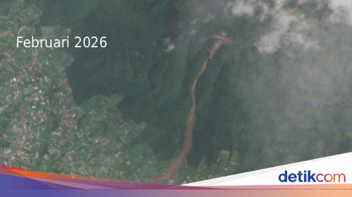
Satellite imagery reveals a dramatic transformation on the slopes of Mount Burangrang, Cisarua subdistrict, West Bandung Regency, in less than a year.
Images from May 2025 show a lush, green landscape dominating the hillsides, with dense vegetation covering the slopes. The area appeared stable, with homes nestled peacefully alongside the mountainside. However, images taken in February 2026 tell a different story. A long, reddish-brown scar cuts across the slope from top to bottom. The path of the landslide is clearly visible, with vegetation replaced by exposed soil and debris.
The line indicates the direction of the landslide, moving from the peak down towards the lower areas. The pattern is consistent, suggesting a significant volume of material moved along the natural slope. The soil at the bottom appears muddier than in previous images, indicating sediment reaching areas near the settlements.
Rangkuman Pencarian Korban
Search and rescue teams were deployed immediately after the landslide struck Mount Burangrang in Cisarua, West Bandung Regency. The initial evacuation efforts were hampered by ongoing rainfall.
The number of those affected fluctuated as information became available. Early reports indicated 111 people were impacted, including six confirmed deaths, 21 survivors, and 84 still missing. It was initially unclear whether all 84 were buried by the landslide or had evacuated independently.
Incident Commander Ade Zakir later updated the figures to 158 people affected, with 78 survivors and 80 people buried. Reports also surfaced that 23 soldiers were among the victims, having been conducting training exercises on Mount Burangrang.
The search continued despite the unpredictable weather. When conditions allowed, around 3,000 personnel were involved in the operation. In the first week, teams recovered 60 body bags, leaving approximately 20 victims still to be found.
On the seventh day, the Search and Rescue Mission Coordinator and Incident Commander decided to extend the search for another week, aligning with the emergency response period declared by the Bandung Barat Regency government.
After 14 days, 48 homes were destroyed and 80 people were confirmed dead, while hundreds more were displaced. On Friday, February 6, 2026, the state of emergency was officially lifted. By the conclude of the emergency response operation, search teams had recovered 94 body bags from the list of 80 missing people. These were handed over to the DVI (Disaster Victim Identification) team of the West Java Police for identification.
According to an official release from the Indonesian Police’s DVI unit on February 6, 2026, at 2:00 PM local time, 74 victims had been identified from 77 body bags, with the remaining bags still undergoing forensic analysis.
Although the state of emergency has ended, the search for victims continues during the transition to the recovery phase, with a limited operational pattern. The National Search and Rescue Agency (Basarnas) and other involved units stated they remain prepared to follow up on any new findings or information regarding potential buried victims.
Throughout the 22-day operation, search teams recovered 101 body bags. A total of 83 victims have been identified by the Disaster Victim Identification (DVI) team of the West Java Police.
Halaman 2 dari 2
(yum/yum) –>
Penyebab Longsor Cisarua
Acting Head of the Geological Agency, Lana Saria, stated that the area affected by the landslide is a hilly region with a high population density and intensive land use.
“The morphology of the research area is dominated by volcanic hilly landscapes with medium to high altitudes. Slope angles generally range between 8° – 40° with moderate to steep slope classes. On some parts of the slope, especially around valleys and ridge lines, very steep slopes with angles greater than 40° are found. The morphological genesis of this area is controlled by the activity of ancient volcanoes resulting in thick volcanic deposits, which then undergo intensive weathering, erosion, and denudation, forming unstable slopes,” Lana said in an official statement.
Geologically, Lana explained, the area is composed of rock units comparable to the undifferentiated ancient volcanic deposits (QVu) as listed in the Regional Geological Map of the Bandung Sheet, West Java.
“This unit generally consists of volcanic breccia, tuff, andesite-basalt lava, and pyroclastic material that has undergone strong weathering. Advanced weathering conditions cause a decrease in soil and rock shear strength, increasing vulnerability to landslides, especially on moderate to steep slopes,” she added.
Lana explained that the Bandung Barat Regency region is regionally influenced by a geological structure system consisting of faults and fractures oriented dominantly northwest-southeast and southwest-northeast, related to the tectonic dynamics of the Bandung Basin and Quaternary volcanic activity.
The presence of structural geological features in the form of fracture and fault zones implies increased rock permeability and the development of weak planes that can act as landslide slip planes. Locally, this structure accelerates weathering and water infiltration into the slope.
“The drainage pattern in this area generally forms a dendritic to sub-dendritic pattern that develops on relatively homogeneous volcanic rocks. Modest to medium-sized rivers follow steep valleys and function as slope release zones. Local hydrogeological conditions are characterized by a shallow groundwater system with a groundwater level that easily rises during heavy rainfall. Intensive rainfall infiltration into weathered volcanic rock layers causes a significant increase in pore water pressure,” she explained.
land use around the location is dominated by residential areas, dryland agriculture, mixed gardens, and some open spaces. Slope cutting for settlements and access roads, as well as inadequate surface drainage systems, also affect slope stability and increase the potential for landslides.
Regarding landslide potential, based on the Landslide Hazard Zonation Map (ZKGT), the location is included in the Medium Landslide Hazard Zone. In this zone, landslides can occur, especially on slopes that have been disturbed naturally or by human activity.
This disaster highlights the strong link between steep morphology, weathered volcanic rocks, geological structures, and high rainfall in triggering large-scale landslides. The main controlling factors of landslides in this location include geological conditions in the form of weathered old volcanic rocks, steep slopes, and the presence of geological structures in the form of fractures and faults.
“The main triggering factor is heavy rainfall that occurred before and during the incident, which caused increased pore water pressure, decreased soil shear strength, and slope failure,” she added.
the mechanism of the landslide is thought to have begun with rainwater infiltration into the weathered volcanic rock layers. The accumulation of water increases pore water pressure and reduces cohesion and shear angle in the slope material. When the driving force on the slope exceeds the resisting force, a movement of soil and rock mass occurs along the developed slip plane, triggering a large-scale landslide.
“The landslide event in Pasirlangu Village, Cisarua Subdistrict, Bandung Barat Regency, is the result of an interaction between regional and local geological conditions, steep morphology, land use, and triggering factors in the form of heavy rainfall. The characteristics of weathered old volcanic rocks and the presence of geological structures increase the region’s vulnerability to landslides, especially in the Medium ZKGT zone,” she explained