Thailand’s upper regions are experiencing hot daytime temperatures, with scattered thunderstorms expected, particularly in the lower Central region and the East, according to a forecast issued Monday, March 17, 2026, by the Thai Meteorological Department. The forecast indicates that a weak high-pressure system or cool air mass from China continues to cover the upper Northeast and the South China Sea, while southerly and southeasterly winds are drawing moisture from the Gulf of Thailand and the South China Sea into the country’s upper areas.
Residents in these areas are advised to be cautious of hazards associated with thunderstorms and to take precautions to protect their health from the increasing heat.
Southern Thailand is also forecast to see isolated thunderstorms as easterly winds prevail over the Gulf of Thailand, the South, and the Andaman Sea. The lower Gulf of Thailand will experience waves of 1-2 meters, potentially exceeding 2 meters during thunderstorms. Mariners in the Gulf of Thailand and the Andaman Sea are urged to proceed with caution and avoid navigating areas with stormy weather.
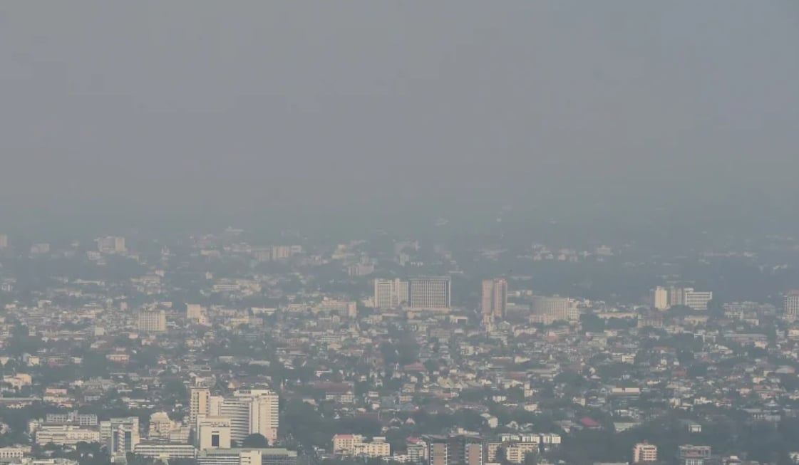
Air quality across much of Thailand is currently listed as moderate to fairly high due to limited air circulation and the accumulation of dust and smoke.
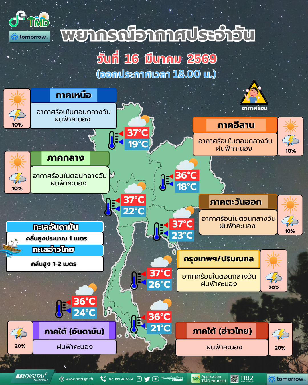
Here’s a more detailed regional breakdown for the period from 6:00 AM today, March 17, to 6:00 AM tomorrow, March 18:
Northern Thailand: Hot daytime temperatures with a 10 percent chance of thunderstorms, primarily in Mae Hong Son, Chiang Mai, Chiang Rai, Tak, Kamphaeng Phet, Uttaradit, Phitsanulok, and Phetchabun provinces. Lows will range from 18-22 degrees Celsius, while highs will reach 33-38 degrees Celsius. Winds will be southeasterly at 10-15 km/hr.
Northeast Thailand: Hot daytime temperatures with a 10 percent chance of thunderstorms, mainly in Loei, Chaiyaphum, and Nakhon Ratchasima provinces. Lows will be 18-22 degrees Celsius, and highs will be 34-36 degrees Celsius. Winds will be easterly at 10-15 km/hr.
Central Thailand: Hot daytime temperatures with a 10 percent chance of thunderstorms, particularly in Uthai Thani, Kanchanaburi, Ratchaburi, Nakhon Pathom, Samut Sakhon, and Samut Songkhram provinces. Lows will be 24-25 degrees Celsius, and highs will be 35-38 degrees Celsius. Winds will be southeasterly at 10-15 km/hr.
Eastern Thailand: Hot daytime temperatures with a 20 percent chance of thunderstorms, especially in Prachinburi, Chachoengsao, Chonburi, Rayong, Chanthaburi, and Trat provinces. Lows will be 21-26 degrees Celsius, and highs will be 32-37 degrees Celsius. Winds will be southeasterly at 15-30 km/hr. Seas will be approximately 1 meter high, with waves potentially exceeding 2 meters during thunderstorms.
Southern Thailand (East Coast): A 10 percent chance of thunderstorms, primarily in Phetchaburi, Prachuap Khiri Khan, and Chumphon provinces. Lows will be 22-25 degrees Celsius, and highs will be 33-36 degrees Celsius. From Chumphon northward, winds will be southeasterly at 15-30 km/hr, with seas around 1 meter high, potentially exceeding 2 meters during thunderstorms. From Surat Thani southward, winds will be southeasterly at 15-35 km/hr, with seas 1-2 meters high, and waves potentially exceeding 2 meters during thunderstorms.
Southern Thailand (West Coast): A 10 percent chance of thunderstorms, mainly in Ranong, Phang Nga, and Krabi provinces. Lows will be 24-26 degrees Celsius, and highs will be 34-36 degrees Celsius. Winds will be easterly at 15-30 km/hr, with seas around 1 meter high, and waves potentially exceeding 1 meter further offshore and during thunderstorms.
Bangkok and Surrounding Areas: Hot daytime temperatures with a 10 percent chance of thunderstorms. Lows will be 24-26 degrees Celsius, and highs will be 33-36 degrees Celsius. Winds will be southerly at 10-15 km/hr.