
A dramatic weather swing is forecast for Poland this week, bringing frigid temperatures to the east and hazardous icy conditions to the west. Temperatures as low as -18°C (0°F) are expected in northeastern regions, while areas in the west brace for a thaw and the risk of freezing rain. Authorities have placed the Territorial Defense Force on standby in western Poland, prepared to mobilize within six hours as conditions deteriorate.
Check the weather forecast for your region on POGODA.WP.PL.
Key Developments:
Table of Contents
- Temperatures in eastern regions will plummet to as low as -18°C (0°F) overnight, while western areas experience a thaw and freezing rain.
- Up to 9 cm (3.5 inches) of snow is expected in northeastern Poland on Wednesday, with a mix of rain and snow, and icy conditions in the west.
- The Territorial Defence Force has placed units on standby in western Poland, prepared to mobilize within six hours.
Poland is bracing for a dramatic weather shift as colliding air masses are set to bring extreme temperature differences and hazardous travel conditions across the country. While temperatures in the northeast could drop to -18°C (0°F), a thaw is expected in the west.
Where Will It Be Coldest and Should Drivers Expect Icy Roads?
The overnight hours will see a stark contrast in temperatures across the country. Residents of northeastern Poland should prepare for bitterly cold conditions. The Suwałki region and Podlasie province will see lows of -15°C (5°F), with some areas dropping to -18°C (0°F). Temperatures in central Poland are expected to be around -8°C (18°F).
A completely different weather pattern will prevail in western and southwestern Poland, where temperatures will hover around 0°C (32°F) to 1°C (34°F). Unfortunately, the warmer air brings with it a mix of rain and snow, which will freeze on the ground, creating dangerous icy conditions.
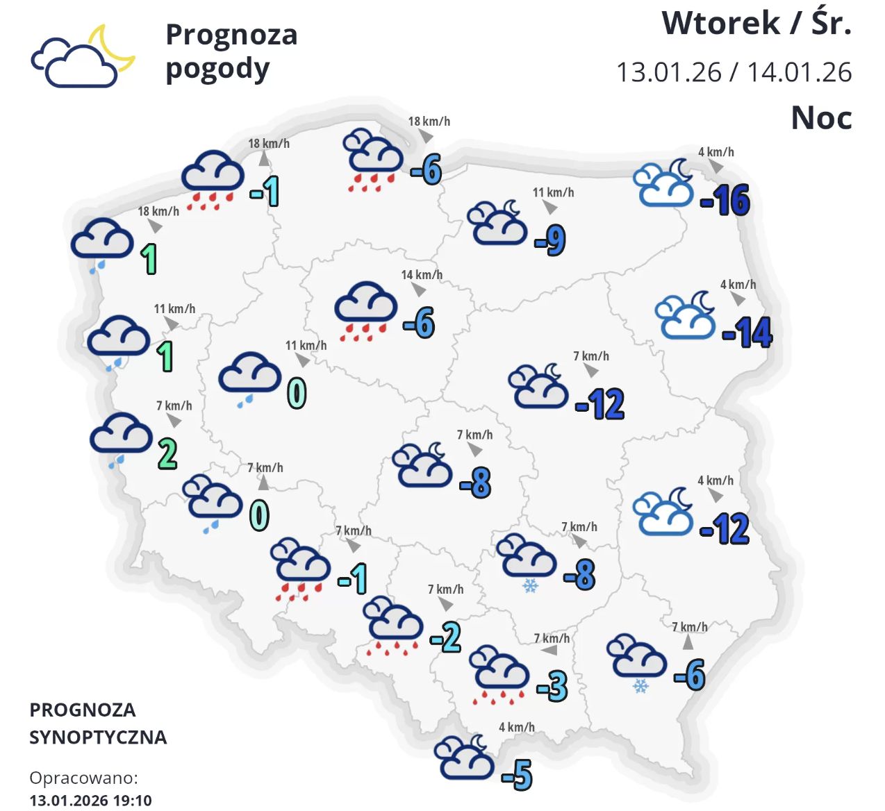

Drivers should be aware that dense fog (visibility down to 300 meters) could reduce visibility in western Poland.
Front Moving Across Poland
A weather front moving across Poland is expected to bring dynamic conditions and significant temperature swings in the coming hours. The country is experiencing a clash of air masses, leading to these varied conditions.
- West and Southwest – Temperatures will be the warmest here, reaching up to 5°C (41°F). Rain is expected.
- Central Poland and Transition Zone: A mix of snow and rain will gradually transition to rain. There is a risk of freezing rain, causing flash freezes on roads and sidewalks.
- East and Northeast (Lublin region, Podlasie, Masuria): Winter conditions will persist. Snow will fall throughout the day (accumulating 5-10 cm / 2-4 inches), and temperatures will remain below freezing (-8°C to -5°C / 18°F to 23°F).
Strong winds are expected in the mountains (gusts up to 80 km/h / 50 mph in the Sudetes), which could create blowing snow conditions.

The division of weather patterns across the country is expected to continue through the middle of the week, although temperatures in the east will moderate slightly.
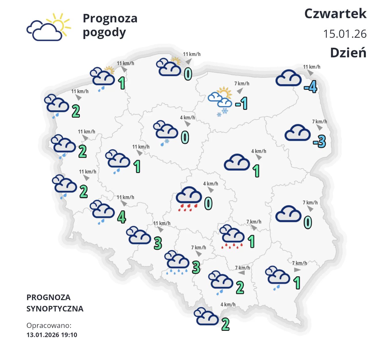
- Overnight (January 14-15): Additional snowfall is expected in eastern Poland (Podlasie and Lublin regions), adding another 5-10 cm (2-4 inches). The rest of the country will see rain or drizzle, which could freeze in the east. Temperatures will range from -9°C to -5°C (16°F to 23°F) in the east.
- During the day (January 15): Cloudy skies will prevail. Temperatures will be above freezing in most areas, reaching up to 4°C (39°F) in the west, with localized drizzle or snow.
The weather divide is expected to continue through the middle of the week, though the severe cold in the east will ease somewhat.
The Territorial Defence Force has placed units on standby, prepared to mobilize within six hours in western Poland, as icy conditions pose a significant risk.
The weekend is forecast to bring continued clear skies, but also a return of very cold temperatures, especially overnight.
From Friday to Saturday and Saturday to Sunday, temperatures in northeastern and eastern Poland could drop dramatically, reaching -13°C to -18°C (9°F to 0°F).
During the day on Saturday, temperatures will remain well below freezing in this area, down to -10°C (14°F), while the southwest will enjoy temperatures of 2-4°C (36-39°F). Sunday will bring plenty of sunshine with little cloud cover, but the frigid air will remain in the east, with overnight lows around -15°C (5°F) and around -9°C (16°F) in the center.
The beginning of next week is expected to bring stable weather and even more sunshine, as cloud cover will be minimal.
The high-pressure system will favor significant temperature drops at night due to radiative cooling. From Monday to Tuesday, frost will cover almost the entire country – reaching -13°C (9°F) in the east and -1°C to -5°C (31°F to 23°F) in the center and west.
During the day, the temperature divide will persist: the northeast will remain frigid with sub-zero temperatures, while the west and south will see highs of up to 3°C (37°F). Winds will generally be light, with occasional gusts in mountainous areas.