
A notable winter storm is set to bring hazardous travel conditions to much of southern and central Quebec beginning Friday. While snowfall amounts will vary across the region, forecasters warn of heavy snow bands and strong winds capable of creating near-zero visibility, particularly in mountainous areas [[1]]. Travelers should monitor forecasts and consider delaying or altering plans as conditions develop.
Published November 27, 2025 at 9:36 PM
A widespread but scattered snow system is expected to complicate travel Friday across several regions of Quebec.
In Brief:
Table of Contents
-
Temperatures are dropping Friday, increasing the likelihood of snow in many areas;
-
Heavy snow bands are possible starting in the morning, with periods of near-zero visibility;
-
Accumulations of 4 to 6 inches are expected in some locations, with higher amounts in mountainous areas;
-
Wind gusts of 25 to 30 mph could further reduce visibility.
Quebec residents should prepare for potentially hazardous travel conditions Friday as a significant snow system moves through the region. The storm, while scattered, is expected to bring heavy snowfall and strong winds to parts of southern and central Quebec.
Difficult-to-Predict Snow Bands
Heavy snow bands could develop as early as Friday morning, becoming more intense in the afternoon. These bands are expected to create dangerous and unpredictable road conditions. The combination of atmospheric instability and orographic lift – where air is forced upward by terrain – means conditions can change rapidly, even over short distances.
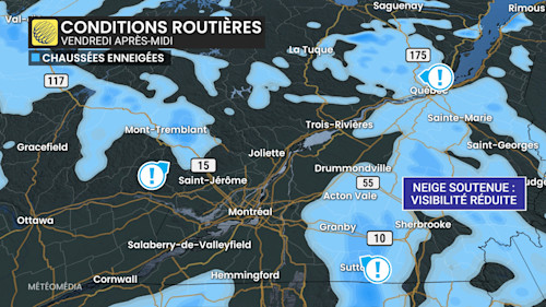
The Laurentians, near Mont-Tremblant, and much of the Eastern Townships are particularly vulnerable. Major roadways could be affected, including Autoroute 10 between Bromont and Sherbrooke, as well as Autoroute 15 and Route 117 north of Saint-Jérôme. Route 175 in the Laurentian Mountains is also an area to watch.
Localized, Significant Accumulations Possible
While the event is highly localized, some areas could see surprisingly high snowfall totals. Models suggest locations like Sutton could receive 6 inches or more by Friday evening. Similar accumulations are possible in parts of the Eastern Townships and in the mountainous regions of the Laurentians.
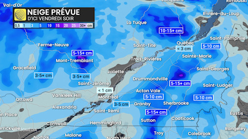
Elsewhere, accumulations will vary significantly, with many areas receiving between 3 and 6 inches, while Montreal is expected to see less than an inch.
Strong Winds to Worsen Conditions
Wind gusts of 25 to 30 mph are expected in many areas during the afternoon, increasing to 40 mph in Monteregie and the Eastern Townships. This combination of heavy snow and strong winds could create blizzard-like conditions with near-zero visibility.